

For 39 years, Race Across America (RAAM) has been challenging ultra cyclists from around the globe to push their physical and mental limits to the farthest reaches. The current edition of RAAM will start on the shores of the Pacific Ocean in Oceanside, California and end on Chesapeake Bay, an estuary of the Atlantic Ocean, in Annapolis, Maryland. The Race will cover roughly 3,000 miles, with over 179,000 feet of climbing, while passing through 12 states.
The route travels west to east, traversing three major mountain ranges (Sierra, Rocky and Appalachian), crosses four of America’s longest rivers (Colorado, Mississippi, Missouri and Ohio) and the Great Plains. Also, passing through such iconic American landmarks as the Mojave and Sonoran Deserts, Monument Valley, Great Plains, and Gettysburg.
Open to amateur and professional racers, in solo, 2-, 4- and 8-person relay teams, there is no other race in the world comparable to RAAM. The Race has become a global icon, having had over 35 countries represented. Not only has RAAM proved to be one of the most challenging races in the world, but has become a huge platform for racers to raise awareness and money for charities of their choice. Racers have raised over $2 million per year over the past 5 years.
2022 RAAM Roster
Follow RAAM and RAW and cheer on the racers!
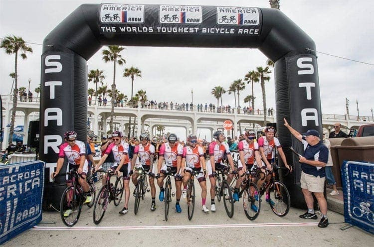
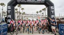
All races start at the Oceanside, California Pier.
- Solo RAAM started on June 14
- Solo and Team RAW started on June 14
- Team RAAM starts at Noon PST, Saturday, June 18
Follow with Live Tracking
RAAM Live Tracking
RAW Live Tracking
2022 RAAM Route
The current edition of RAAM will start on the shores of the Pacific Ocean in Oceanside, California and end on Chesapeake Bay, an estuary of the Atlantic Ocean, in Annapolis, Maryland. The Race will cover roughly 3,000 miles, with over 179,000 feet of climbing, while passing through 12 states.
A racer once described the RAAM route as, “A couple of big hills with some flat stuff in between.” In some respects that is true. After leaving the Pacific Shores, the route crosses the Coast Range, the deserts of the American Southwest, climbs up onto the Coconino Plateau, passes through the Navajo Reservation, Monument Valley, the Four Corners Area, climbs the Rocky Mountains and descends to the Great Plains. After crossing the Plains, the route traverses the farm lands of the central US, crosses the Appalachian Range and descends to Chesapeake Bay, an estuary on the Atlantic Ocean.
Along the way, racers cross four of the five great American Rivers, the Colorado, Missouri, Mississippi and Ohio and all three major mountain chains, the Coast Range, Rockies and Appalachians. RAAM uses facilities provided by the City of Oceanside for the various start-related activities – check-in (Harbor Lot 1) and race-start (The Strand and West Community Center parking lot), all located in the vicinity of the Oceanside Pier. Parking is located on the bluff immediately above these facilities.
RAAM employs a “time trial” and “parade” start. Racers will leave the parking lot west of the Beach Community Center at intervals and travel via police escort along the Strand, up Surfrider, north on Cleveland to the San Luis Rey River Bike Trail and east to Mance Buchanon Park on College Avenue, where the parade start ends and racing begins. This time of year, temperatures on the Coast will average 60 to 80F. Weather is generally cool and somewhat foggy in the morning, clearing in the afternoon. Racers will travel inland and gradually gain elevation. Climbing toward the crest of the Coast Range, the skies will clear and the humidity will drop. After cresting out at roughly 4,200 feet, racers will descend “the glass elevator” to the Anza Borrego Desert and Imperial Valley where temperatures are likely to be in the 100 to 120F range with extremely low humidity, generally 5 to 10%.
Racers will travel around the south side of the Salton Sea (235 feet below sea level), through irrigated farmland and desert sand dunes to Blythe on the Colorado River. From there they will proceed north up the Colorado River Valley, crossing into Arizona just south of Parker. Desert-like conditions – low humidity, triple-digit day time temperatures – will persist through Congress and up Yarnell Grade to the Prescott National Forest. At this point Racers will have climbed over 6,000 feet from the Colorado River crossing.
From Prescott the route crosses up and over 7,000 foot Mingus Mountain and descends through Jerome into the Verde River Valley and the town of Cottonwood. This section is characterized by narrow and winding roads with few turnouts. Leaving Cottonwood, the route heads east across I-17 to Camp Verde. From there the route crosses the Verde River at an elevation of 3,000 feet, climbs up over the Mogollon Rim onto the Coconino Plateau and north to Flagstaff.
Race RVs are not allowed on certain sections of the route between Yarnell and Flagstaff. Also, auxiliary support vehicles not required for this section should use the alternate routing to avoid being trapped into illegal caravanning on the narrow mountain roads. Alternate routing will take the non-essential support vehicles via limited access highways to the Camp Verde and Flagstaff Time Stations.
Elevations on the Coconino Plateau will be 5,000 to 7,000 feet. Days will be 80 to 100F and nights 50 to 60F with clear skies and low humidity. Similar conditions should persist across the Navajo Reservation, through Monument valley, all the way across the “Four Corners Area” into the mountains of Colorado. The Four Corners is the only place in the US where 4 states touch – Arizona, Utah, Colorado and New Mexico.
Between Flagstaff and Colorado, the route traverses high desert with spectacular rock formations. Upon entering Colorado the high desert gives way to the Rocky Mountains. Actually, the Rockies are comprised of a series of mountain ranges. Mancos Mountain and Hesperus Hill on the southwest edge of the San Juan are polite introductions to more significant climbs to follow.
Crossing the San Juan, racers climb to 11,000 foot Wolf Creek Pass, the highest point on the RAAM route. There racers cross the Continental Divide – the line where rivers on the west flow to the Pacific Ocean and on the east flow to the Gulf of Mexico and Atlantic Ocean. In the mountains of Colorado, temperatures range from 50 to 80F in the day and 30 to 50F at night. Afternoon storms are common. Snow, sleet and freezing rain may be encountered. The route then drops down into the San Luis Valley before climbing over the Sangre de Cristo Range, the easternmost range in the Rockies. Riders must climb La Veta and Cuchara Passes before dropping down into Trinidad. At Trinidad, the terrain changes dramatically.
Leaving Trinidad, the racers head out across the Great Plains. The sparsely populated Plains, with day time temperatures in the range of 80 to 100F and rainfall less than 15 inches per year, are sometimes referred to as the Great America Desert. The Plains were formerly the home of millions of free-ranging American Bison or Buffalo and Native American tribes. In the 1800s, when the settlers pushed west, the Buffalo were killed, Native Americans were driven to reservations, railroads were built and large cattle ranching operations were established. Today the Plains are now largely irrigated farmland and cattle range.
The Great Plains are nearly 700 miles across, exceptionally flat and characterized by weather fronts that produce unpredictable winds, dramatic temperature changes, large storms with heavy rain, hail, lightning and occasional tornadoes. The volatile weather on the Great Plains is the result of cold air from the Arctic colliding with warm, moist air from the Gulf of Mexico. The weather on the Plains can determine whether this will or will not be a RAAM for the record books. Race crews monitoring weather fronts, able to catch favorable winds and having correct gearing can gain significant advantage. One racer and crew may catch favorable winds and weather while another might not be so lucky. Weather can play a huge role.
The RAAM half-way point is near Pratt, Kansas.
As racers cross the Plains, skirt Wichita and pass into the hills and lakes of Missouri, the humidity will gradually rise. This represents the transition from the Great Plains to another major physiographic region, the Eastern Woodlands. The Plains give way to rolling terrain characterized by alternating farms and wooded areas. In eastern Kansas and Missouri the humidity can approach 80 to 90%. Higher temperatures and humidity will characterize the remainder of the route.
Midway across Missouri, the route crosses two widely separated arms of the Lake of the Ozarks, between which racers and crew will be forced to contend with an overabundance of vacationing motorists. After passing through the capital of Missouri, racers will drop down into the Missouri River Valley. After a flat section, racers will encounter a series of steep short climbs on their way over into the Mississippi River Valley, where they will skirt the north edge of St. Louis and cross the Mississippi River at Alton, Illinois. The elevation of the Mississippi at this point is roughly 400 feet. The region near the confluence of the Missouri and Mississippi Rivers is frequently subject to flooding. Reroutes are not uncommon in this region.
The route is essentially flat across southern Illinois and much of Indiana. As you approach Bloomington, Indiana, the terrain becomes increasingly hilly, navigation becomes tricky. Failing to re-zero an odometer at a time station can make navigating difficult and substantially increase the potential for going off-route. Passing through Bloomington, racers cross the Indiana University campus, and can catch a glimpse of the stadium where the “Little 500” bicycle race is held every year. The race was the subject of what is, arguably, the best cycling film ever made, “Breaking Away”, the classic coming of age battle between university students and townies known as “cutters.” The cutters were from working class families, the sons of parents whose income was derived primarily from working in the local limestone quarries.
The route becomes increasingly hilly across southern Ohio and into West Virginia. Racers cross the Ohio River, another of North America’s great rivers, at Parkersburg, West Virginia. West Virginia is coal mining country. Watch out for heavy trucks hauling coal at high speeds on narrow roads.
Past Parkersburg, the most difficult climbing in RAAM begins. Endless 250- to 500-foot “rollers” become 500- to 1,000-foot climbs, with grades of 8 to 10% or more, as racers and crew work their way across the Appalachian Range.
The high point in the Appalachians is between McHenry and Grantsville, MD – roughly 3,000 feet. The section between Cumberland and Hancock, Maryland is the most difficult section of RAAM, as measured in feet of climbing per mile. Racers can expect temperatures in the 80 to 90F range with high humidity. Rainfall and thunder storms are common. The combination of endless steep climbs, high temperatures and humidity, after having ridden 2,500 miles, make crossing the Appalachians particularly difficult.
After Hancock, the hills become increasingly moderate as the route crosses the Eastern Appalachian Foothills on the way to the Atlantic Coastal Plain. Racers parallel the Pennsylvania-Maryland border. At Rouzerville, Pennsylvania racers head south to Mt. Airy, Maryland.
From Mt. Airy, racers head east and gradually descend toward the Atlantic Coastal Plain. Racers will proceed through residential communities and rolling country south across the “Washington – Baltimore Corridor”. The corridor is characterized by an extensive network of limited access highways carrying traffic between the major East Coast metropolitan areas. The route avoids all but a few miles of limited access highway. There are several miles of limited access highway shoulder where bikes are allowed, if not expected. The route passes around the Patuxent River Wildlife Preserve as well as Fort Meade, home of the National Security Agency (NSA), and on toward Annapolis, Maryland.
A Race Official will meet racers there and escort them the remaining few miles through Annapolis to Susan Campbell Park at City Dock. The short trip from the Shell Station to City Dock is a “parade finish” – no racing. The actual Finish is in Susan Campbell Park at City Dock. Racers must finish the ride to City Dock to become an Official Finisher.
The Race Across America – the World’s Toughest Bicycle Race is over 3,000 miles with more than 170,000 feet of climbing coast-to-coast across America. Colonial Annapolis has many small restaurants and bars and is reminiscent of many European cities. It’s time to celebrate…go for it!


%20Gets%20Underway%20in%20Oceanside)